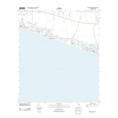
2012 Map of Grayton Beach
USGS Topo · Published 2012About this map
Grayton Beach and its neighboring coastal communities are defined by a rare series of coastal dune lakes situated just behind the Gulf of Mexico shoreline. In this 2012 landscape, specialized water bodies like Oyster Lake, Draper Lake, Big Redfish Lake, Little Redfish Lake, and Western Lake pocket the coastline, creating a distinct hydrological pattern where freshwater and saltwater ecosystems meet. This era of development shows the planned growth of resort communities such as Watercolor, Seaside, and Seagrove Beach to the east, while the Santa Rosa Cemetery near Dune Allen Beach remains a point of local historical continuity.
Find a feature on this map
53 named features on this map. Tap any name to fly to it.
Don’t see what you’re looking for? This feature index may not catch every label — zoom into the map to look around manually.
Map Details
Editions of this 2012 Grayton Beach Map
This is the sole edition of this map. No revisions or reprints were ever made.
Other maps of this area

1935 · Villa Tasso
USGS Topo · 1:48,000

1936 · Point Washington
USGS Topo · 1:48,000

1938 · Villa Tasso
USGS Topo · 1:62,500

1939 · Point Washington
USGS Topo · 1:62,500

1956 · Villa Tasso
USGS Topo · 1:62,500

1957 · Pensacola
USGS Topo · 1:250,000

1959 · Pensacola
USGS Topo · 1:250,000

1960 · Pensacola
USGS Topo · 1:250,000
1970 · Bunker
USGS Topo · 1:24,000
1970 · Miramar Beach
USGS Topo · 1:24,000