1956 Map of Villa Tasso
USGS Topo · Published 1958About this map
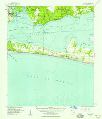
Moreno Point defines the narrow peninsula separating Choctawhatchee Bay from the Gulf of Mexico, a landscape of coastal dune lakes and bayous in the mid-1950s. The settlement of Destin is visible at the western tip near Norreigo Pt, where the Destin Sch served the local community. Much of the northern shoreline is dominated by Eglin Air Force Base, featuring warning zones for danger unexploded bombs and numerous small inlets such as Boggy Bayou and Rocky Bayou. A remarkable chain of coastal freshwater lakes, including Stalworth Lake, Campbell Lake, and Fuller Lake, lines the southern coast near Topsail Hill. These natural features, combined with the presence of the remote settlement at Villa Tasso, illustrate the Emerald Coast before its era of intensive resort development, showing the original county line between Okaloosa and Walton counties.
Find a feature on this map
60 named features on this map. Tap any name to fly to it.
Don’t see what you’re looking for? This feature index may not catch every label — zoom into the map to look around manually.
Map Details
Editions of this 1956 Villa Tasso Map
2 editions found

Other maps of this area

1934 · Holt
USGS Topo · 1:48,000

1934 · Niceville
USGS Topo · 1:48,000

1935 · Villa Tasso
USGS Topo · 1:48,000

1935 · De Funiak Springs
USGS Topo · 1:48,000

1936 · Niceville
USGS Topo · 1:62,500

1936 · Point Washington
USGS Topo · 1:48,000

1937 · Holt
USGS Topo · 1:62,500

1938 · Mary Esther
USGS Topo · 1:62,500

1938 · Villa Tasso
USGS Topo · 1:62,500

1938 · De Funiak Springs
USGS Topo · 1:62,500