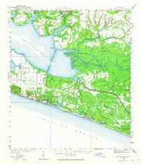
1936 Map of Point Washington
USGS Topo · Published 1964About this map
Choctawhatchee Bay dominates this coastal landscape, where the northern shore is defined by a complex network of inlets such as La Grange Bayou and Alaqua Bayou. In the mid-1930s, the southern strip of Walton County shows the early development of coastal communities like Grayton Beach and Seagrove Beach along the Gulf of Mexico. Further inland, the settlement of Point Washington sits at the junction of the bay and the Intracoastal Waterway, which cuts through the dense wetlands of Devils Swamp. The map details a transition from the commercial fishing and logging environments of Freeport and Liberty in the north to the emerging beachfront character in the south. Notable features of this era include the Lookout Tower 44 and a series of coastal dune lakes, including Western Lake and Lake Powell, which remain rare geographical features of the Florida Panhandle.
Find a feature on this map
65 named features on this map. Tap any name to fly to it.
Don’t see what you’re looking for? This feature index may not catch every label — zoom into the map to look around manually.
Map Details
Editions of this 1936 Point Washington Map
2 editions found
Other maps of this area

1934 · Niceville
USGS Topo · 1:48,000

1935 · Villa Tasso
USGS Topo · 1:48,000

1935 · De Funiak Springs
USGS Topo · 1:48,000

1936 · Niceville
USGS Topo · 1:62,500

1936 · Point Washington
USGS Topo · 1:48,000

1938 · Villa Tasso
USGS Topo · 1:62,500

1938 · De Funiak Springs
USGS Topo · 1:62,500

1939 · Point Washington
USGS Topo · 1:62,500

1943 · Laguna Beach
USGS Topo · 1:31,680

1943 · Seminole Hills
USGS Topo · 1:24,000