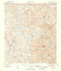
1951 Map of Glendale
USGS Topo · Published 1951About this map
The Alabama-Florida state line divides this 1951 topographic survey, where the rolling pinelands of Walton County meet the southern reaches of the Conecuh National Forest. Small farming settlements and crossroads communities like Gaskin, Glendale, and Darlington anchor a landscape defined by an intricate network of wetlands, including Big Swamp-Annez, Peasly Bay, and Pikehole Bay. These "bays" and ponds reflect the unique hydrology of the coastal plain, providing natural boundaries for early settlers. Local life at the mid-century mark centered on numerous rural congregations and resting places, such as Danley Hill Ch, Friendship Ch, and Ray Cem. A notable geographic landmark, the Natural Bridge, sits in the northwest near Natural Bridge Creek, while the Pea River serves as a major drainage on the eastern edge of the quadrangle, illustrating the importance of river systems to the regional economy.
Find a feature on this map
101 named features on this map. Tap any name to fly to it.
Don’t see what you’re looking for? This feature index may not catch every label — zoom into the map to look around manually.
Map Details
Editions of this 1951 Glendale Map
2 editions found

Other maps of this area

1934 · Niceville
USGS Topo · 1:48,000

1935 · De Funiak Springs
USGS Topo · 1:48,000

1936 · Niceville
USGS Topo · 1:62,500

1938 · De Funiak Springs
USGS Topo · 1:62,500

1942 · Enterprise
USGS Topo · 1:125,000

1948 · Ponce De Leon
USGS Topo · 1:24,000

1949 · Glendale
USGS Topo · 1:62,500

1949 · Laurel Hill
USGS Topo · 1:62,500

1949 · Hobbs Crossroads
USGS Topo · 1:24,000

1950 · Hobbs Cross Roads
USGS Topo · 1:24,000