
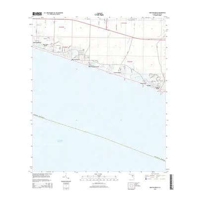
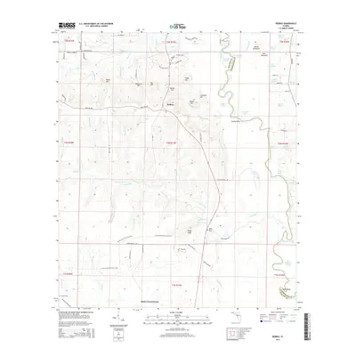
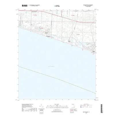
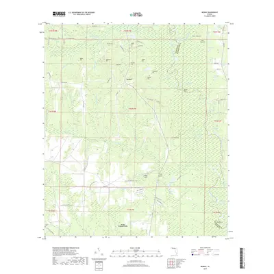
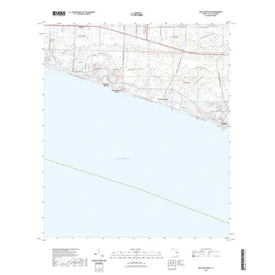
1970 Map of Choctaw Beach
USGS Topo · Published 1977About this map
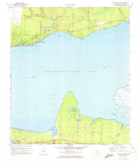
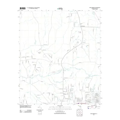
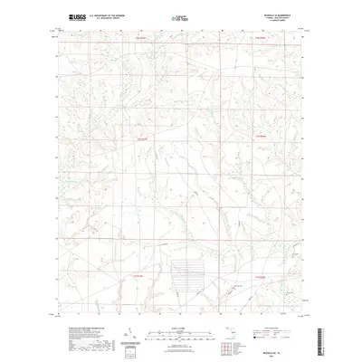
Choctaw Beach occupies the northern shoreline of Choctawhatchee Bay in this early 1970s survey, showing a landscape defined by the proximity of Eglin Air Force Base. The northern half of the map is dominated by military reservation lands, where creeks like Piney Creek and Mullet Creek drain southward into Grassy Cove. Along the coastline, the Intracoastal Waterway cuts through the bay, while the southern shore is marked by a series of deep inlets including Buck Bayou, Mack Bayou, and the large Hogtown Bayou. Small coastal lakes such as Sharon Lake and Horseshoe Lake sit near the water's edge, separated by narrow stretches of land. This era shows the developed Fort Rucker Recreation Area and Roadside Park serving as recreational hubs along the bay shore, providing a look at the integration of military facilities and public coastal access during this period of Florida's Panhandle history.
Find a feature on this map
31 named features on this map. Tap any name to fly to it.
Don’t see what you’re looking for? This feature index may not catch every label — zoom into the map to look around manually.
Map Details
Editions of this 1970 Choctaw Beach Map
2 editions found
Historical Maps of Miramar Beach Through Time
125 maps found

1935 De Funiak Springs
Walton County, FL

1935 Villa Tasso
Walton County, FL

1936 Point Washington
Walton County, FL

1938 De Funiak Springs
Walton County, FL

1938 Villa Tasso
Walton County, FL

1939 Point Washington
Walton County, FL

1944 Bruce
Walton County, FL

1945 Bruce
Walton County, FL

1948 Ponce De Leon
Walton County, FL

1949 Glendale
Walton County, FL

1949 Redbay
Walton County, FL

1950 Ponce De Leon
Walton County, FL

1950 Redbay
Walton County, FL

1951 Glendale
Walton County, FL

1956 Villa Tasso
Walton County, FL

1970 Bunker
Walton County, FL
1970 Choctaw Beach
Walton County, FL

1970 Grayton Beach
Walton County, FL

1970 Niceville SE
Walton County, FL

1970 Point Washington
Walton County, FL

1970 Portland
Walton County, FL

1970 Rock Hill
Walton County, FL

1973 Darlington
Walton County, FL

1973 De Funiak Springs East
Walton County, FL

1973 De Funiak Springs West
Walton County, FL

1973 Gaskin
Walton County, FL

1973 Glendale
Walton County, FL

1973 Liberty
Walton County, FL

1973 Mossy Head
Walton County, FL

1973 New Harmony
Walton County, FL

1974 Point Washington
Walton County, FL

1982 Bruce
Walton County, FL

1982 Ponce De Leon
Walton County, FL

1982 Redbay
Walton County, FL

1987 Darlington
Walton County, FL

1994 Choctaw Beach
Walton County, FL

1994 Ponce De Leon
Walton County, FL

1996 Point Washington
Walton County, FL

2012 Bruce
Walton County, FL

2012 Bunker
Walton County, FL

2012 Choctaw Beach
Walton County, FL

2012 Darlington
Walton County, FL

2012 De Funiak Springs East
Walton County, FL

2012 De Funiak Springs West
Walton County, FL
2012 Gaskin
Walton County, FL

2012 Glendale
Walton County, FL
2012 Grayton Beach
Walton County, FL

2012 Liberty
Walton County, FL
2012 Mossy Head
Walton County, FL
2012 New Harmony
Walton County, FL
2012 Niceville SE
Walton County, FL

2012 Point Washington
Walton County, FL

2012 Portland
Walton County, FL

2012 Redbay
Walton County, FL

2012 Rock Hill
Walton County, FL

2015 Bruce
Walton County, FL

2015 Bunker
Walton County, FL

2015 Choctaw Beach
Walton County, FL
2015 Darlington
Walton County, FL

2015 De Funiak Springs East
Walton County, FL

2015 De Funiak Springs West
Walton County, FL
2015 Gaskin
Walton County, FL

2015 Glendale
Walton County, FL
2015 Grayton Beach
Walton County, FL

2015 Liberty
Walton County, FL
2015 Mossy Head
Walton County, FL
2015 New Harmony
Walton County, FL
2015 Niceville SE
Walton County, FL

2015 Point Washington
Walton County, FL

2015 Portland
Walton County, FL
2015 Redbay
Walton County, FL

2015 Rock Hill
Walton County, FL

2018 Bruce
Walton County, FL
2018 Bunker
Walton County, FL

2018 Choctaw Beach
Walton County, FL
2018 Darlington
Walton County, FL

2018 De Funiak Springs East
Walton County, FL

2018 De Funiak Springs West
Walton County, FL
2018 Gaskin
Walton County, FL

2018 Glendale
Walton County, FL
2018 Grayton Beach
Walton County, FL

2018 Liberty
Walton County, FL
2018 Mossy Head
Walton County, FL
2018 New Harmony
Walton County, FL
2018 Niceville SE
Walton County, FL

2018 Point Washington
Walton County, FL

2018 Portland
Walton County, FL
2018 Redbay
Walton County, FL

2018 Rock Hill
Walton County, FL

2021 Bruce
Walton County, FL
2021 Bunker
Walton County, FL

2021 Choctaw Beach
Walton County, FL

2021 Darlington
Walton County, FL

2021 De Funiak Springs East
Walton County, FL
2021 De Funiak Springs West
Walton County, FL
2021 Gaskin
Walton County, FL

2021 Glendale
Walton County, FL
2021 Grayton Beach
Walton County, FL
2021 Liberty
Walton County, FL
2021 Mossy Head
Walton County, FL
2021 New Harmony
Walton County, FL
2021 Niceville SE
Walton County, FL

2021 Point Washington
Walton County, FL

2021 Portland
Walton County, FL
2021 Redbay
Walton County, FL
2021 Rock Hill
Walton County, FL

2024 Bruce
Walton County, FL

2024 Bunker
Walton County, FL

2024 Choctaw Beach
Walton County, FL

2024 Darlington
Walton County, FL

2024 De Funiak Springs East
Walton County, FL

2024 De Funiak Springs West
Walton County, FL

2024 Gaskin
Walton County, FL

2024 Glendale
Walton County, FL
2024 Grayton Beach
Walton County, FL

2024 Liberty
Walton County, FL

2024 Mossy Head
Walton County, FL

2024 New Harmony
Walton County, FL

2024 Niceville SE
Walton County, FL

2024 Point Washington
Walton County, FL

2024 Portland
Walton County, FL

2024 Redbay
Walton County, FL

2024 Rock Hill
Walton County, FL

2025 Grayton Beach
Walton County, FL

2025 Point Washington
Walton County, FL