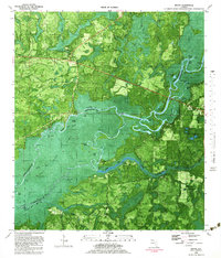
1982 Map of Bruce
USGS Topo · Published 1983About this map
The Choctawhatchee River dominates this 1980s landscape, winding through a complex system of sloughs, cutoffs, and river-fed lakes along the border of Walton and Washington Counties. The presence of numerous landings, such as Miller Landing, Cedar Tree Landing, and Cedar Bluff Landing, points to the historical importance of the river as a transportation corridor and resource for local communities. The settlement of Bruce sits near the headwaters of Black Creek, while Ebro anchors the eastern edge of the map near a local Clay Pit.
Find a feature on this map
68 named features on this map. Tap any name to fly to it.
Don’t see what you’re looking for? This feature index may not catch every label — zoom into the map to look around manually.
Map Details
Editions of this 1982 Bruce Map
2 editions found
Other maps of this area

1935 · De Funiak Springs
USGS Topo · 1:48,000

1936 · Point Washington
USGS Topo · 1:48,000

1938 · De Funiak Springs
USGS Topo · 1:62,500

1939 · Point Washington
USGS Topo · 1:62,500

1943 · Seminole Hills
USGS Topo · 1:24,000

1943 · West Bay
USGS Topo · 1:24,000

1944 · Seminole Hills
USGS Topo · 1:31,680

1944 · West Bay
USGS Topo · 1:31,680

1944 · Bruce
USGS Topo · 1:24,000

1945 · Red Head
USGS Topo · 1:31,680