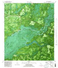
1982 Map of Bruce
USGS Topo · Published 1983About this map
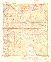
The Choctawhatchee River winds through a dense network of sloughs, oxbow lakes, and landings in this 1982 orthophotomap of the Florida Panhandle. The landscape is defined by the shifting waters of the river corridor, which forms the boundary between Walton and Washington counties. Settled communities like Bruce and Ebro sit on the higher ground flanking the swampy bottomlands, connected by the paths of Highway 81 and Highway 79. The eastern portion of the sheet is dominated by the Pine Log State Forest, where the Gunlock Cem stands as a quiet marker of local family history near the banks of Big Cypress Creek. From the winding Horseshoe Bend to the industrial Clay Pit near the Washington and Bay county lines, this map captures a rural environment where timber, transport, and the river economy intersect.
Find a feature on this map
64 named features on this map. Tap any name to fly to it.
Don’t see what you’re looking for? This feature index may not catch every label — zoom into the map to look around manually.
Map Details
Editions of this 1982 Bruce Map
2 editions found

Other maps of this area

1935 · De Funiak Springs
USGS Topo · 1:48,000

1936 · Point Washington
USGS Topo · 1:48,000

1938 · De Funiak Springs
USGS Topo · 1:62,500
1939 · Point Washington
USGS Topo · 1:62,500

1943 · Seminole Hills
USGS Topo · 1:24,000

1943 · West Bay
USGS Topo · 1:24,000
1944 · Seminole Hills
USGS Topo · 1:31,680
1944 · West Bay
USGS Topo · 1:31,680

1944 · Bruce
USGS Topo · 1:24,000
1945 · Red Head
USGS Topo · 1:31,680