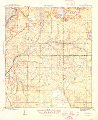
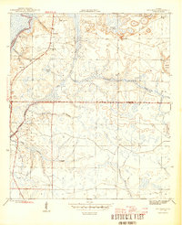
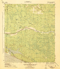
1945 Map of Red Head
USGS Topo · Published 1945About this map
The Choctawhatchee River defines the northwestern boundary of this mid-1940s landscape, where the rural communities of Red Head and Ebro anchor the local social geography. Along the river, Rocky Landing and Douglas Bay indicate a history of water-based activity, while the interior is a complex network of wetlands and creeks such as Log Creek, Botheration Creek, and Burnt Mill Creek. The presence of the Oak Grove Ch, Red Head Sch, and the Ebro Cem provides critical points of interest for genealogists tracing family roots in this part of Florida. Much of the southern terrain is dominated by the Pine Log State Forest, marked by the Moody Fire Tower overlooking the wooded plains and ponds like Blue Pond. The map captures the region just as the established Base Line survey demarcated the borders between Washington and Bay counties.
Find a feature on this map
24 named features on this map. Tap any name to fly to it.
Don’t see what you’re looking for? This feature index may not catch every label — zoom into the map to look around manually.
Map Details
Editions of this 1945 Red Head Map
4 editions found

Other maps of this area

1943 · Seminole Hills
USGS Topo · 1:24,000

1943 · West Bay
USGS Topo · 1:24,000

1943 · Southport
USGS Topo · 1:24,000
1944 · Southport
USGS Topo · 1:24,000
1944 · Seminole Hills
USGS Topo · 1:31,680
1944 · West Bay
USGS Topo · 1:31,680

1944 · Crystal Lake
USGS Topo · 1:24,000

1944 · Bruce
USGS Topo · 1:24,000
1945 · Bruce
USGS Topo · 1:31,680
1945 · Crystal Lake
USGS Topo · 1:31,680