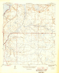
1945 Map of Red Head
USGS Topo · Published 1945About this map
The Choctawhatchee River defines the western edge of this mid-1940s landscape, where the shifting boundaries of Walton, Washington, and Bay counties meet. The small settlement of Red Head serves as a local focal point, supported by the Red Head Sch and the nearby Oak Grove Ch. The terrain is deeply intertwined with water, featuring a network of curiously named drainages such as Botheration Creek, Graveyard Creek, and Burnt Mill Creek.
Find a feature on this map
21 named features on this map. Tap any name to fly to it.
Don’t see what you’re looking for? This feature index may not catch every label — zoom into the map to look around manually.
Map Details
Editions of this 1945 Red Head Map
4 editions found
Other maps of this area

1943 · Seminole Hills
USGS Topo · 1:24,000

1943 · West Bay
USGS Topo · 1:24,000

1943 · Southport
USGS Topo · 1:24,000

1944 · Southport
USGS Topo · 1:24,000

1944 · Seminole Hills
USGS Topo · 1:31,680

1944 · West Bay
USGS Topo · 1:31,680

1944 · Crystal Lake
USGS Topo · 1:24,000

1944 · Bruce
USGS Topo · 1:24,000

1945 · Red Head
USGS Topo · 1:31,680

1945 · Bruce
USGS Topo · 1:31,680