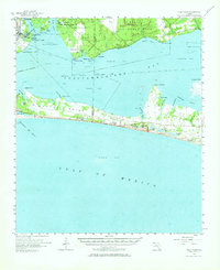
1956 Map of Villa Tasso
USGS Topo · Published 1966About this map
Eglin Air Force Base dominates the northern landscape, where military operations define the geography of the mid-1950s. The map illustrates a unique period of mid-century coastal development, showing the transition from the established community of Valparaiso to the emerging fishing and tourism hub of Destin on the southern peninsula. Between these points, the waters of Choctawhatchee Bay are segmented by extensive military restricted zones, including areas labeled for Danger Unexploded Bombs, reflecting the intense Cold War-era utility of the Panhandle coast. Along the narrow strip of Moreno Point, a string of coastal lakes such as Stewart Lake and Fuller Lake sit just behind the dunes near Topsail Hill, while the interior remains sparsely settled with small outposts like Postil and Dixon. This record captures the precise moment before the Florida Emerald Coast underwent the massive residential expansion that would eventually link these scattered settlements.
Find a feature on this map
57 named features on this map. Tap any name to fly to it.
Don’t see what you’re looking for? This feature index may not catch every label — zoom into the map to look around manually.
Map Details
Editions of this 1956 Villa Tasso Map
2 editions found

Other maps of this area

1934 · Holt
USGS Topo · 1:48,000

1934 · Niceville
USGS Topo · 1:48,000

1935 · Villa Tasso
USGS Topo · 1:48,000

1935 · De Funiak Springs
USGS Topo · 1:48,000

1936 · Niceville
USGS Topo · 1:62,500

1936 · Point Washington
USGS Topo · 1:48,000

1937 · Holt
USGS Topo · 1:62,500

1938 · Mary Esther
USGS Topo · 1:62,500

1938 · Villa Tasso
USGS Topo · 1:62,500

1938 · De Funiak Springs
USGS Topo · 1:62,500