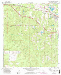
1973 Map of De Funiak Springs West
USGS Topo · Published 1988About this map
The Louisville and Nashville railroad corridor anchors the northern reaches of this Florida panhandle landscape, connecting the growing western suburbs of De Funiak Springs to smaller outlying settlements like Alpine Heights and Louisville. This era of the mid-1970s shows a transitional terrain where the edge of Eglin Air Force Base meets a working countryside dotted with extractive industry, evidenced by numerous sandpits and claypits found near Ionia.
Find a feature on this map
46 named features on this map. Tap any name to fly to it.
Don’t see what you’re looking for? This feature index may not catch every label — zoom into the map to look around manually.
Map Details
Editions of this 1973 De Funiak Springs West Map
4 editions found
Other maps of this area

1934 · Niceville
USGS Topo · 1:48,000

1935 · De Funiak Springs
USGS Topo · 1:48,000

1936 · Niceville
USGS Topo · 1:62,500

1938 · De Funiak Springs
USGS Topo · 1:62,500

1949 · Glendale
USGS Topo · 1:62,500

1949 · Laurel Hill
USGS Topo · 1:62,500

1950 · Laurel Hill
USGS Topo · 1:62,500

1951 · Glendale
USGS Topo · 1:62,500

1956 · Niceville
USGS Topo · 1:62,500

1957 · Pensacola
USGS Topo · 1:250,000