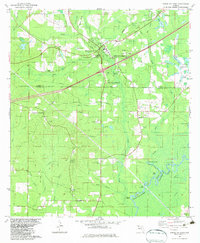
1982 Map of Ponce De Leon
USGS Topo · Published 1983About this map
The Choctawhatchee River defines the southeastern boundary of this Florida Panhandle landscape, where the confluence of numerous creeks and spring runs creates a water-rich geography. At the heart of the map lies Ponce de Leon and the Ponce de Leon Springs State Recreation Area, centered on natural aquifer outflows like Jackson Spring. The region’s infrastructure is shaped by the Seaboard Coast Line railroad and a network of rural crossroads including Douglass Crossroads and the settlement at Knox Hill. Local genealogy is well-represented through numerous country churches and burial grounds, such as Andrew Chapel, Mt Zion Ch, and the St Paul Hill Cem. The terrain transitions from higher ground at Gopher Ridge and Sheep Hill down to the low-lying basin of Morrison Spring Run, reflecting a classic Gulf Coast coastal plain environment.
Find a feature on this map
63 named features on this map. Tap any name to fly to it.
Don’t see what you’re looking for? This feature index may not catch every label — zoom into the map to look around manually.
Map Details
Editions of this 1982 Ponce De Leon Map
2 editions found
Other maps of this area

1935 · De Funiak Springs
USGS Topo · 1:48,000

1938 · De Funiak Springs
USGS Topo · 1:62,500

1948 · Ponce De Leon
USGS Topo · 1:24,000

1949 · Glendale
USGS Topo · 1:62,500

1949 · Millers Ferry
USGS Topo · 1:24,000

1949 · Redbay
USGS Topo · 1:24,000

1949 · Hinsons Cross Roads
USGS Topo · 1:24,000

1949 · Caryville
USGS Topo · 1:24,000

1950 · Prosperity
USGS Topo · 1:24,000

1950 · Millers Ferry
USGS Topo · 1:24,000