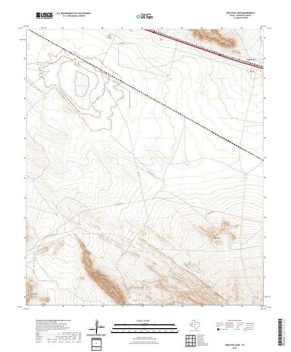
2022 Map of Grayton Lake
USGS Topo · Published 2022About this map
Grayton Lake and the surrounding Trans-Pecos desert landscape define this high-altitude basin in Hudspeth County. The terrain is a network of arid drainage patterns and water management features essential for ranching in this dry environment. To the north, the broad expanse of Eagle Flat is accessed by remote thoroughfares like Box Car Rd and Wilkins Rd. The topography rises sharply toward the south and east, where Little Hills and the prominent Love Hogback interrupt the plains. Cattle ranching history is etched into the landscape through numerous named water catchments, including Malo Suerte Tank, Hackett Tank, and Partition Tank. These features, along with the distinct Red Hills and Red Hills Arroyo, provide a clear picture of how land use and hydrology are intertwined in this corner of West Texas.
Find a feature on this map
22 named features on this map. Tap any name to fly to it.
Don’t see what you’re looking for? This feature index may not catch every label — zoom into the map to look around manually.
Map Details
Editions of this 2022 Grayton Lake Map
This is the sole edition of this map. No revisions or reprints were ever made.
Other maps of this area

1895 · Sierra Blanca
USGS Topo · 1:125,000

1897 · Eagle Mountain
USGS Topo · 1:125,000

1916 · Eagle Mountain
USGS Topo · 1:125,000

1954 · Van Horn
USGS Topo · 1:250,000

1958 · Van Horn
USGS Topo · 1:250,000

1959 · Marfa
USGS Topo · 1:250,000
1963 · Grayton Lake
USGS Topo · 1:24,000

1964 · Devil Ridge
USGS Topo · 1:24,000
1964 · Allamoore
USGS Topo · 1:24,000

1964 · Dome Peak
USGS Topo · 1:24,000