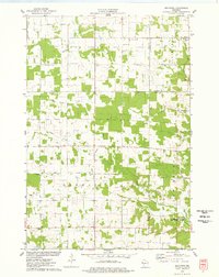
1975 Map of Graytown
USGS Topo · Published 1978About this map
The northern reaches of the Willow River and the rural intersection of four Wisconsin counties—Polk, Barron, St. Croix, and Dunn—characterize this mid-1970s landscape. Agriculture and woodlots define the township of Forest, where a network of small churches and community buildings serves the scattered farmsteads. Local genealogy is rooted in sites like St Johns Ch, Immanuel Ch, and the Seventh-day Adventist Ch, along with several cemeteries and the Sunnyside Sch. The eastern edge of the survey features the settlements of Graytown and Reeve, the latter situated near the headwaters of the South Fork Hay River. An interesting industrial remnant is the Old Grade Railroad, which cuts a straight line through the undulating terrain, indicating the historical transport patterns of the region's earlier timber or farming eras. Conservation land is also prominent at the Bolen Creek State Public Hunting Grounds in the southeast corner.
Find a feature on this map
26 named features on this map. Tap any name to fly to it.
Don’t see what you’re looking for? This feature index may not catch every label — zoom into the map to look around manually.
Map Details
Editions of this 1975 Graytown Map
This is the sole edition of this map. No revisions or reprints were ever made.
Other maps of this area

1948 · Downing
USGS Topo · 1:62,500

1950 · Downing
USGS Topo · 1:62,500

1950 · Deer Park
USGS Topo · 1:62,500

1950 · Balsam Lake
USGS Topo · 1:62,500

1950 · Turtle Lake
USGS Topo · 1:62,500

1952 · Turtle Lake
USGS Topo · 1:62,500

1953 · Stillwater
USGS Topo · 1:250,000

1955 · Stillwater
USGS Topo · 1:250,000

1958 · Stillwater
USGS Topo · 1:250,000

1965 · Stillwater
USGS Topo · 1:250,000