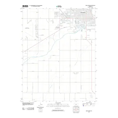
2009 Map of Great Bend
USGS Topo · Published 2009About this map
Great Bend serves as the hub of this 2009 survey, showcasing a dense grid of streets and residential development situated just north of the Arkansas River. The city’s infrastructure is clearly defined, from the Great Bend Municipal Airport on the western edge to the centrally located Great Bend Cemetery. South of the river, the landscape transitions into the expansive Great Bend Prairie, a low-lying region marked by the winding path of Antelope Creek.
Find a feature on this map
71 named features on this map. Tap any name to fly to it.
Don’t see what you’re looking for? This feature index may not catch every label — zoom into the map to look around manually.
Map Details
Editions of this 2009 Great Bend Map
This is the sole edition of this map. No revisions or reprints were ever made.
Other maps of this area

1891 · Great Bend
USGS Topo · 1:125,000

1893 · Great Bend
USGS Topo · 1:125,000

1955 · Great Bend
USGS Topo · 1:250,000

1956 · Ellinwood NW
USGS Topo · 1:24,000

1957 · Great Bend
USGS Topo · 1:250,000

1957 · Ellinwood SW
USGS Topo · 1:24,000

1958 · Great Bend
USGS Topo · 1:250,000

1958 · Great Bend
USGS Topo · 1:24,000

1959 · Great Bend NE
USGS Topo · 1:24,000

1960 · Pawnee Rock
USGS Topo · 1:24,000