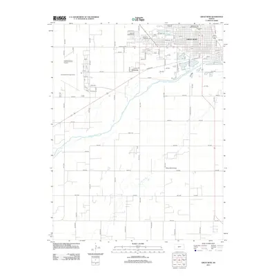
2012 Map of Great Bend
USGS Topo · Published 2012About this map
The Arkansas River winds across this landscape, defining the southern boundary of Great Bend and shaping the local geography. This 2012 survey illustrates the modern layout of the city, highlighting the integration of municipal services and recreational spaces like the Great Bend Zoo and the Wetlands at Great Bend Aquatic Facility. To the west, the Great Bend Municipal Airport and the Sunflower Rod and Custom Association Dragstrip occupy the site of a former military airfield, a common pattern for postwar development in the Kansas plains. South of the river, the terrain transitions into the Great Bend Prairie, where the drainage of Antelope Cr and the alignment of Liberty Rd mark the transition into more rural territory. The map also identifies local landmarks such as the Great Bend Cem and the settlement of Anchorway.
Find a feature on this map
91 named features on this map. Tap any name to fly to it.
Don’t see what you’re looking for? This feature index may not catch every label — zoom into the map to look around manually.
Map Details
Editions of this 2012 Great Bend Map
This is the sole edition of this map. No revisions or reprints were ever made.
Other maps of this area

1891 · Great Bend
USGS Topo · 1:125,000

1893 · Great Bend
USGS Topo · 1:125,000

1955 · Great Bend
USGS Topo · 1:250,000

1956 · Ellinwood NW
USGS Topo · 1:24,000

1957 · Great Bend
USGS Topo · 1:250,000

1957 · Ellinwood SW
USGS Topo · 1:24,000

1958 · Great Bend
USGS Topo · 1:250,000

1958 · Great Bend
USGS Topo · 1:24,000

1959 · Great Bend NE
USGS Topo · 1:24,000

1960 · Pawnee Rock
USGS Topo · 1:24,000