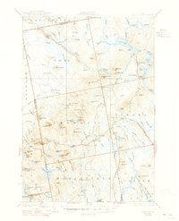
1932 Map of Great Pond
USGS Topo · Published 1947About this map
Amherst and North Mariaville anchor the southern reaches of this interior Maine landscape, where the Airline Road and the Whales Back Route traverse the glacial terrain of Hancock County. The map provides a clear look at early 20th-century rural infrastructure, documenting several local schools such as Longfellow Sch and Grover Sch, alongside isolated outposts like KP Camp and Bragg Camp. The geography is defined by a complex network of glacial features, most notably the distinctive ridge labeled Horseback and numerous named summits including Spruce Mtn and Bald Mountain. In the north, Great Pond and its namesake Great Pond P O sit amidst a high concentration of water bodies like Alligator Stream and Rift Pond, illustrating the importance of these waterways for logging and local transit before the modernization of the regional road network.
Find a feature on this map
125 named features on this map. Tap any name to fly to it.
Don’t see what you’re looking for? This feature index may not catch every label — zoom into the map to look around manually.
Map Details
Editions of this 1932 Great Pond Map
4 editions found

Other maps of this area

1900 · Orland
USGS Topo · 1:62,500

1902 · Orono
USGS Topo · 1:62,500

1911 · Ellsworth
USGS Topo · 1:62,500

1917 · Passadumkeag
USGS Topo · 1:62,500

1929 · Great Pond
USGS Topo · 1:48,000

1929 · Lead Mountain
USGS Topo · 1:48,000

1930 · Tunk Lake
USGS Topo · 1:48,000

1931 · Saponac
USGS Topo · 1:48,000

1932 · Tunk Lake
USGS Topo · 1:62,500

1932 · Nicatous Lake
USGS Topo · 1:48,000