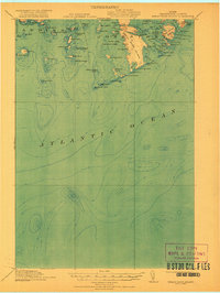
1921 Map of Great Wass Island
USGS Topo · Published 1921About this map
Great Wass Island and the intricate archipelago of Jonesport define this coastal survey of the Maine shoreline just after the First World War. The map details a complex maritime landscape of deep harbors and tidal narrows, including the Main Channel Way and the sheltered waters of Mistake Harbor. Navigation aids and safety installations are prominent, specifically the Moose Peak L H on Mistake Island and a Coast Guard Sta positioned on the western shore of the main island. From the rugged protrusion of Moose Neck to the outlying Seahorse Rock, the chart captures a moment when the regional economy remained deeply tied to the sea. Notable family-named landmarks like Stevens Island, Plummer Island, and Alleys Pt provide essential geographic points for genealogists tracing the coastal history of Washington County.
Find a feature on this map
76 named features on this map. Tap any name to fly to it.
Don’t see what you’re looking for? This feature index may not catch every label — zoom into the map to look around manually.
Map Details
Editions of this 1921 Great Wass Island Map
4 editions found
Other maps of this area

1902 · Cherryfield
USGS Topo · 1:62,500

1904 · Cherryfield
USGS Topo · 1:62,500

1904 · Petit Manan
USGS Topo · 1:62,500

1918 · Machias
USGS Topo · 1:62,500

1921 · Great Wass Island
USGS Topo · 1:62,500

1921 · Columbia Falls
USGS Topo · 1:62,500

1941 · Columbia Falls
USGS Topo · 1:62,500

1941 · Machias
USGS Topo · 1:62,500

1942 · Cherryfield
USGS Topo · 1:62,500

1942 · Columbia Falls
USGS Topo · 1:62,500