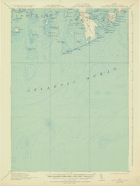
1921 Map of Great Wass Island
USGS Topo · Published 1932About this map
Great Wass Island anchors this maritime survey of the Washington County coast, where the Atlantic meets a complex archipelago of granite ledges and deep-water harbors. The topography is dominated by the seafaring infrastructure of the era, notably the Moose Peak L H on Mistake Harbor and the Coast Guard Sta positioned along the western shore of the main island. The map reveals the intricate network of coves and narrows that defined local navigation, from Cape Split Harbor in the west to the sheltered waters of Head Harbor. Notable interior features like The Pond on the island's southern reach suggest a landscape of both saltwater and freshwater interaction. Numerous outlying islands, such as Nash Island and Drisco Island, are depicted with detailed soundings, providing a clear record of the treacherous bathymetry and sheltered anchorages used by Maine's coastal mariners during the early twentieth century.
Find a feature on this map
80 named features on this map. Tap any name to fly to it.
Don’t see what you’re looking for? This feature index may not catch every label — zoom into the map to look around manually.
Map Details
Editions of this 1921 Great Wass Island Map
4 editions found
Other maps of this area

1902 · Cherryfield
USGS Topo · 1:62,500

1904 · Cherryfield
USGS Topo · 1:62,500

1904 · Petit Manan
USGS Topo · 1:62,500

1918 · Machias
USGS Topo · 1:62,500

1921 · Great Wass Island
USGS Topo · 1:62,500

1921 · Columbia Falls
USGS Topo · 1:62,500

1941 · Columbia Falls
USGS Topo · 1:62,500

1941 · Machias
USGS Topo · 1:62,500

1942 · Cherryfield
USGS Topo · 1:62,500

1942 · Columbia Falls
USGS Topo · 1:62,500