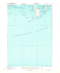
1921 Map of Great Wass Island
USGS Topo · Published 1944About this map
Great Wass Island anchors this coastal survey, serving as a prominent landmark in the archipelago south of Jonesport. The map depicts an intricate network of narrow channels and ledge formations, including the Tabbott Narrows and Main Channel Way, which were vital for maritime navigation along the Washington County coast. At the turn of the 1920s, the maritime infrastructure of the region was well-defined by the presence of the Coast Guard Sta on the western shore of the main island and the Moose Peak L H on the outer reach of Mistake Harbor.
Find a feature on this map
82 named features on this map. Tap any name to fly to it.
Don’t see what you’re looking for? This feature index may not catch every label — zoom into the map to look around manually.
Map Details
Editions of this 1921 Great Wass Island Map
4 editions found
Other maps of this area

1902 · Cherryfield
USGS Topo · 1:62,500

1904 · Cherryfield
USGS Topo · 1:62,500

1904 · Petit Manan
USGS Topo · 1:62,500

1918 · Machias
USGS Topo · 1:62,500

1921 · Great Wass Island
USGS Topo · 1:62,500

1921 · Columbia Falls
USGS Topo · 1:62,500

1941 · Columbia Falls
USGS Topo · 1:62,500

1941 · Machias
USGS Topo · 1:62,500

1942 · Cherryfield
USGS Topo · 1:62,500

1942 · Columbia Falls
USGS Topo · 1:62,500