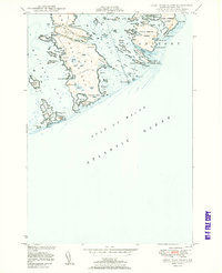
1950 Map of Great Wass Island
USGS Topo · Published 1950About this map
Great Wass Island and its surrounding archipelago dominate this mid-century hydrographic and topographic study of the Washington County coastline. The landscape is defined by a intricate network of tidal coves and heaths, with a solitary telephone line providing the primary overland connection through the island's interior toward Three Falls Harbor. Evidence of coastal life and maritime safety is visible at Mannings Farm on the southern reaches and the Moose Peak L H U S Coast Guard Sta situated on Mistake Island. These surveys, compiled from aerial photography and older hydrographic data, capture a moment when traditional maritime navigation relied on prominent coastal landmarks like Red Head and the dangerous Black Ledges in the Mud Hole Channel. Smaller landmasses such as Steele Harbor Island and Head Harbor Island frame the deep-water passages of the Main Channel Way, illustrating the complex navigation required within Western Bay.
Find a feature on this map
69 named features on this map. Tap any name to fly to it.
Don’t see what you’re looking for? This feature index may not catch every label — zoom into the map to look around manually.
Map Details
Editions of this 1950 Great Wass Island Map
3 editions found
Other maps of this area

1918 · Machias
USGS Topo · 1:62,500

1921 · Great Wass Island
USGS Topo · 1:62,500

1921 · Columbia Falls
USGS Topo · 1:62,500

1941 · Columbia Falls
USGS Topo · 1:62,500

1941 · Machias
USGS Topo · 1:62,500

1942 · Columbia Falls
USGS Topo · 1:62,500

1948 · Jonesport
USGS Topo · 1:24,000

1948 · Roque Bluffs
USGS Topo · 1:24,000

1948 · Drisko Island
USGS Topo · 1:24,000
1948 · Addison
USGS Topo · 1:24,000