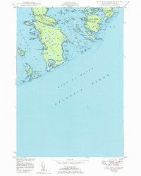
1950 Map of Great Wass Island
USGS Topo · Published 1983About this map
Great Wass Island dominates this mid-century coastal survey, a landscape defined by its intricate network of coves and the surrounding archipelago of Washington County. At the time of this fieldwork, the island's interior was marked primarily by an extensive telephone line and several areas of heath, indicating the specialized wetland ecology of this Down East environment. Evidence of human habitation and navigation is concentrated at the periphery, such as the Mannings Farm on Fisherman Island and the critical maritime infrastructure located on Mistake Island, which includes the Moose Peak L H lighthouse and a U S Coast Guard Sta. The map captures the complex hydrography between Western Bay and Eastern Bay, including sheltered anchorages like Three Falls Harbor and Mistake Harbor. The presence of many named ledges and rocks, such as Norton Ledge and Freeman Rock, highlights the navigational hazards inherent to this portion of the Gulf of Maine.
Find a feature on this map
67 named features on this map. Tap any name to fly to it.
Don’t see what you’re looking for? This feature index may not catch every label — zoom into the map to look around manually.
Map Details
Editions of this 1950 Great Wass Island Map
3 editions found
Other maps of this area

1918 · Machias
USGS Topo · 1:62,500

1921 · Great Wass Island
USGS Topo · 1:62,500

1921 · Columbia Falls
USGS Topo · 1:62,500

1941 · Columbia Falls
USGS Topo · 1:62,500

1941 · Machias
USGS Topo · 1:62,500

1942 · Columbia Falls
USGS Topo · 1:62,500

1948 · Jonesport
USGS Topo · 1:24,000

1948 · Roque Bluffs
USGS Topo · 1:24,000

1948 · Drisko Island
USGS Topo · 1:24,000
1948 · Addison
USGS Topo · 1:24,000