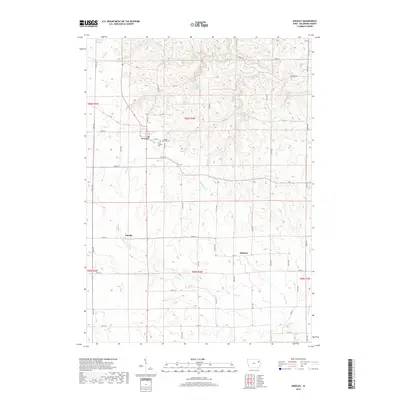
2018 Map of Greeley
USGS Topo · Published 2018About this map
Greeley and the surrounding agricultural landscape of Delaware County are defined by a network of creeks and small drainages that feed the Plum Cr system. This area, surveyed in 2018, shows the persistent settlement patterns of small Iowa communities like Oneida and Almoral. The geography is notably shaped by water features such as Fountain Mill Spring and Fountain Springs Cr, which cut through the township divisions of T90N and T89N. Genealogists will find the locations of Saint Joseph's Cem and Grant View Cem just east of the main settlement at Greeley. The map reveals a highly structured grid of county roads, including Co Hwy D13 and Nature Rd, which facilitate movement between the farmsteads and rural junctions that characterize this portion of the state.
Find a feature on this map
53 named features on this map. Tap any name to fly to it.
Don’t see what you’re looking for? This feature index may not catch every label — zoom into the map to look around manually.
Map Details
Editions of this 2018 Greeley Map
This is the sole edition of this map. No revisions or reprints were ever made.
Other maps of this area
1900 · Anamosa
USGS Topo · 1:125,000
1902 · Elkader
USGS Topo · 1:125,000
1957 · Colesburg
USGS Topo · 1:24,000
1959 · Dubuque
USGS Topo · 1:250,000
1961 · Dubuque
USGS Topo · 1:250,000
1962 · Dubuque
USGS Topo · 1:250,000
1962 · Petersburg
USGS Topo · 1:24,000
1964 · Edgewood
USGS Topo · 1:24,000
1964 · Garber
USGS Topo · 1:24,000
1965 · Thorpe
USGS Topo · 1:24,000