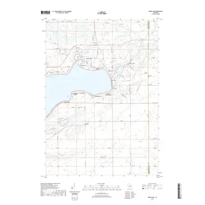
2018 Map of Green Lake
USGS Topo · Published 2018About this map
The deep waters of Green Lake dominate this Wisconsin landscape, where shoreline developments like Oakwood Point and Pleasant Point reveal the area's long-standing appeal as a lakeside retreat. To the north, the Puchyan River and the Puchyan Mill Race indicate a history of water-driven industry near the settlement of Green Lake. The terrain is marked by distinctive elevations and natural features, including Sandstone Bluff overlooking Woods Bay and the specialized topography of Skunk Hollow and Mitchell Glen. Genealogists will find a cluster of burial grounds including Dartford Cem and Lakeview Cem, reflecting the early community centers of the region. The map also captures the local transition toward modern infrastructure with the inclusion of J & L Aviation on the eastern edge near the Green Lake and Fond du Lac county line.
Find a feature on this map
93 named features on this map. Tap any name to fly to it.
Don’t see what you’re looking for? This feature index may not catch every label — zoom into the map to look around manually.
Map Details
Editions of this 2018 Green Lake Map
This is the sole edition of this map. No revisions or reprints were ever made.
Other maps of this area

1915 · Neshkoro
USGS Topo · 1:48,000

1916 · Ripon
USGS Topo · 1:48,000

1918 · Neshkoro
USGS Topo · 1:62,500

1918 · Ripon
USGS Topo · 1:62,500

1955 · Randolph
USGS Topo · 1:62,500

1955 · Fox Lake
USGS Topo · 1:62,500

1956 · Ripon
USGS Topo · 1:62,500

1957 · Madison
USGS Topo · 1:250,000

1960 · Madison
USGS Topo · 1:250,000

1963 · Neshkoro
USGS Topo · 1:62,500
Featured Places
- Green Lake, City of Green Lake
- City of Green Lake, WI
- Brooklyn, WI
- Tuleta Hills, WI
- Green Lake Station, WI