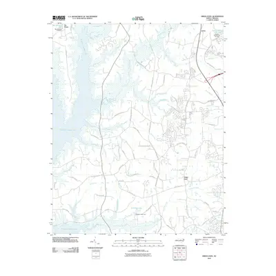
2010 Map of Green Level
USGS Topo · Published 2010About this map
B Everett Jordan Lake dominates the western edge of this landscape, its vast backwaters and inlets reaching toward the growing communities of Green Level and Genlee. The transition from rural farmland to suburban expansion is evident in the dense network of new roads, such as McCrimmon Pkwy and Louis Stephens Dr, which cut across a terrain still defined by numerous creek branches. The American Tobacco Trl serves as a distinct linear corridor through the center, following a former rail alignment that once connected the region's tobacco markets.
Find a feature on this map
72 named features on this map. Tap any name to fly to it.
Don’t see what you’re looking for? This feature index may not catch every label — zoom into the map to look around manually.
Map Details
Editions of this 2010 Green Level Map
This is the sole edition of this map. No revisions or reprints were ever made.
Other maps of this area

1943 · Durham South
USGS Topo · 1:62,500

1946 · Chapel Hill
USGS Topo · 1:24,000

1947 · Chapel Hill
USGS Topo · 1:31,680

1951 · Farrington
USGS Topo · 1:24,000

1951 · Durham South
USGS Topo · 1:62,500

1953 · Raleigh
USGS Topo · 1:250,000

1954 · Raleigh
USGS Topo · 1:250,000

1969 · New Hope Dam
USGS Topo · 1:24,000
1973 · Cary
USGS Topo · 1:24,000
1973 · Green Level
USGS Topo · 1:24,000