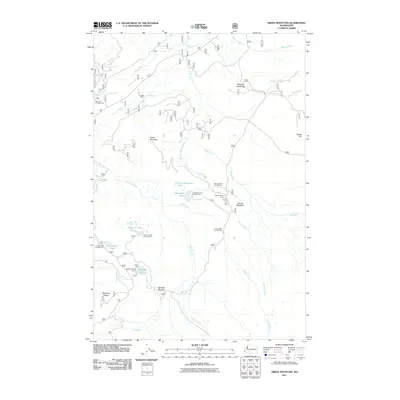
2011 Map of Green Mountain
USGS Topo · Published 2011About this map
Green Mountain stands as a central topographic feature in this high-altitude landscape where the headwaters of the Cispus River and the Lewis River originate. The 2011 survey reveals an intricate network of alpine recreation sites, particularly around the glacial water bodies in the southern portion of the quadrangle. Several established camping areas, including Takhlakh Forest Camp and the Chain of Lakes Campground, indicate the long-standing importance of this area for seasonal forest access. The drainage patterns are defined by the Muddy Fork and Adams Creek, which carve through the terrain beneath Potato Hill and Babyshoe Ridge. This map is especially useful for tracing the precise locations of high-mountain meadows like Takh Takh Meadow and Midway Meadows, which have served as distinct landmarks for navigators and foresters for decades.
Find a feature on this map
31 named features on this map. Tap any name to fly to it.
Don’t see what you’re looking for? This feature index may not catch every label — zoom into the map to look around manually.
Map Details
Editions of this 2011 Green Mountain Map
This is the sole edition of this map. No revisions or reprints were ever made.
Other maps of this area

1904 · Mount Adams
USGS Topo · 1:125,000

1907 · Mount Adams
USGS Topo · 1:125,000

1926 · Steamboat Mtn
USGS Topo · 1:125,000

1931 · Steamboat Mtn
USGS Topo · 1:125,000

1950 · Yakima
USGS Topo · 1:250,000

1958 · Yakima
USGS Topo · 1:250,000

1961 · Yakima
USGS Topo · 1:250,000
1970 · Hamilton Buttes
USGS Topo · 1:24,000
1970 · Blue Lake
USGS Topo · 1:24,000
1970 · East Canyon Ridge
USGS Topo · 1:24,000