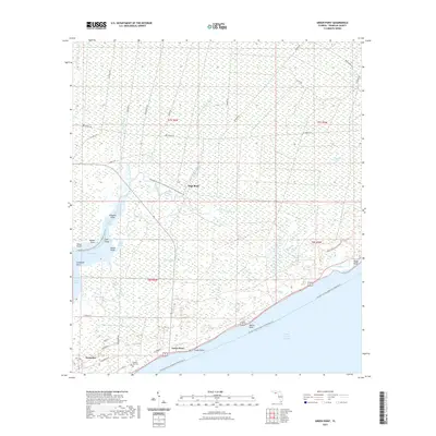
2021 Map of Green Point
USGS Topo · Published 2021About this map
Saint George Sound dominates the southern edge of this coastal survey, where the settlements of Green Point and Eastpoint sit along the shoreline of Franklin County. The landscape is defined by an intricate network of wetlands and tidal waters, including Cash Swamp and Tates Hell Swamp. Along the western margins, East Bay and East Bayou are punctuated by numerous named points such as Alligator Point and Rabbit Point, while the interior is crisscrossed by old forest and logging roads like Dry Bridge Rd and Oil Well Rd. Genealogists may find interest in the Porters Bar Cem located near the southern coast. The presence of the Apalachicola River Wildlife And Environmental Area Trl and the Florida Circumnavigational Paddling Trl highlights the area's modern identity as a protected conservation and recreation corridor.
Find a feature on this map
59 named features on this map. Tap any name to fly to it.
Don’t see what you’re looking for? This feature index may not catch every label — zoom into the map to look around manually.
Map Details
Editions of this 2021 Green Point Map
This is the sole edition of this map. No revisions or reprints were ever made.
Other maps of this area

1943 · Apalachicola
USGS Topo · 1:31,680

1943 · Carrabelle
USGS Topo · 1:24,000

1944 · Pickett Bay
USGS Topo · 1:31,680

1944 · Carrabelle
USGS Topo · 1:31,680

1944 · Green Point
USGS Topo · 1:31,680

1944 · Sugar Hill
USGS Topo · 1:31,680

1944 · Apalachicola
USGS Topo · 1:24,000

1945 · Tates Hell Swamp
USGS Topo · 1:31,680

1945 · Sugar Hill
USGS Topo · 1:31,680

1945 · Beverly
USGS Topo · 1:31,680