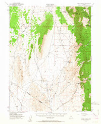
1951 Map of Green Springs
USGS Topo · Published 1963About this map
Mining history dominates the high ridges of the White Pine Range and Pogonip Ridge on this mid-century survey. The northeastern corner is particularly dense with historic extraction sites, including the Ne Plus Ultra Mine, Homestake Mine, and the Grand Prize Mine clustered near Mt Hamilton. These workings and the nearby settlement of Shermantown reflect a legacy of silver and lead mining that transformed this high-altitude landscape.
Find a feature on this map
28 named features on this map. Tap any name to fly to it.
Don’t see what you’re looking for? This feature index may not catch every label — zoom into the map to look around manually.
Map Details
Editions of this 1951 Green Springs Map
4 editions found
Other maps of this area

1949 · Treasure Hill
USGS Topo · 1:62,500

1950 · Treasure Hill
USGS Topo · 1:62,500

1951 · Green Springs
USGS Topo · 1:62,500

1951 · Illipah
USGS Topo · 1:62,500

1951 · Pancake Summit
USGS Topo · 1:62,500

1953 · Pinto Summit
USGS Topo · 1:62,500

1956 · Lund
USGS Topo · 1:250,000

1956 · Ely
USGS Topo · 1:250,000

1957 · Currant Mtn
USGS Topo · 1:62,500

1959 · Ely
USGS Topo · 1:250,000