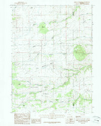
1987 Map of Green Top Mountain
USGS Topo · Published 1987About this map
Medicine Bow National Forest dominates the southern landscape of this high-altitude Wyoming quadrangle, where the headwaters of North Fork Lodgepole Creek and Horse Creek originate. The topography is defined by prominent landmarks such as Green Top Mountain, Eagle Rock, and Bare Knob, revealing a rugged terrain managed for both resource extraction and conservation. The presence of several Mine sites near McKechnie Meadow indicates the region's mineral interests, while the solitary Grave recorded in the northern reaches provides a poignant point of interest for genealogists and local historians. This 1980s survey captures a transition zone between the foothills and higher peaks, where reliable water sources like Artillery Spring and the sprawling Mc Kechnie Meadow supported high-country ranching and forestry operations along the boundary of Albany and Laramie counties.
Find a feature on this map
25 named features on this map. Tap any name to fly to it.
Don’t see what you’re looking for? This feature index may not catch every label — zoom into the map to look around manually.
Map Details
Editions of this 1987 Green Top Mountain Map
This is the sole edition of this map. No revisions or reprints were ever made.
Other maps of this area

1905 · Sherman
USGS Topo · 1:125,000

1948 · Sherman Mountains
USGS Topo · 1:62,500

1948 · Ragged Top Mountain
USGS Topo · 1:62,500

1950 · Ragged Top Mountain
USGS Topo · 1:62,500

1950 · Sherman Mountains
USGS Topo · 1:62,500

1954 · Cheyenne
USGS Topo · 1:250,000

1958 · Cheyenne
USGS Topo · 1:250,000

1962 · Horse Creek
USGS Topo · 1:24,000
1962 · Hecla
USGS Topo · 1:24,000
1962 · Islay
USGS Topo · 1:24,000