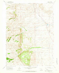
1962 Map of Islay
USGS Topo · Published 1964About this map
Mesa Mountain and the high terrain of Cheyenne Pass dominate this 1962 landscape in Laramie County, where the headwaters of the Lodgepole Creek system begin their descent. The map captures a transition from the elevated western ranges down toward the plains, marked by the distinct branches of North Lodgepole Creek, Middle Lodgepole Creek, and South Lodgepole Creek. Historically significant sites include the Site of Camp Walbach, a mid-19th-century military outpost established to protect travelers on the Lodgepole Creek trail. The presence of several Flowing Wells, an Aqueduct, and early ranching footprints like T Ranch and Lorenz Ranch illustrate the critical importance of water management in this arid cattle country. Transportation is anchored by the Colorado and Southern railroad line, which skirts the eastern edge of the quadrangle near the settlement of Islay.
Find a feature on this map
21 named features on this map. Tap any name to fly to it.
Don’t see what you’re looking for? This feature index may not catch every label — zoom into the map to look around manually.
Map Details
Editions of this 1962 Islay Map
2 editions found
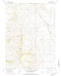
Other maps of this area

1905 · Sherman
USGS Topo · 1:125,000

1948 · Sherman Mountains
USGS Topo · 1:62,500

1948 · Ragged Top Mountain
USGS Topo · 1:62,500

1950 · Ragged Top Mountain
USGS Topo · 1:62,500

1950 · Sherman Mountains
USGS Topo · 1:62,500

1954 · Cheyenne
USGS Topo · 1:250,000

1958 · Cheyenne
USGS Topo · 1:250,000

1962 · Horse Creek
USGS Topo · 1:24,000

1962 · Federal
USGS Topo · 1:24,000

1962 · Dereemer Ranch
USGS Topo · 1:24,000