
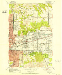
1951 Map of Greenacres
USGS Topo · Published 1951About this map
The Spokane River corridor in the early fifties shows a landscape of rapid post-war industrial and military expansion. Centered around the massive Naval Supply Depot at Velox, the map details a dense concentration of infrastructure supporting the valley's growth. To the west of the depot, an Aluminum Rolling Mill and several industrial sidings like Trentwood Siding indicate the area's manufacturing importance. This economic activity is balanced by established agrarian and community sites, including Otis Orchards and the St Josephs Church.
Find a feature on this map
84 named features on this map. Tap any name to fly to it.
Don’t see what you’re looking for? This feature index may not catch every label — zoom into the map to look around manually.
Map Details
Editions of this 1951 Greenacres Map
2 editions found

Other maps of this area

1901 · Spokane
USGS Topo · 1:125,000

1903 · Oakesdale
USGS Topo · 1:125,000

1903 · Rathdrum
USGS Topo · 1:125,000

1905 · Oakesdale
USGS Topo · 1:125,000

1943 · Mt Spokane
USGS Topo · 1:62,500

1949 · Deer Park
USGS Topo · 1:62,500

1949 · Greenacres
USGS Topo · 1:62,500
1950 · Spokane NE
USGS Topo · 1:24,000
1950 · Spokane SE
USGS Topo · 1:24,000

1950 · Mt Spokane
USGS Topo · 1:62,500