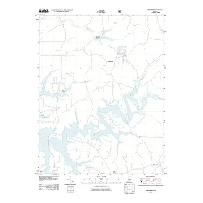
2011 Map of Greenbrier
USGS Topo · Published 2011About this map
Greenbrier sits at the heart of this Southern Indiana landscape, where the headwaters of French Lick Creek and Painter Creek begin to define the undulating terrain. To the south, the expansive waters of the Patoka River system dominate the geography, creating an intricate network of inlets and branches like Cane Branch and Dumplin Branch. This area is characterized by its rural settlement pattern, where small communities like Ethel and Brownstown are linked by winding roads that navigate around the rising elevations of Tillery Hill and Lomax Hollow. The presence of the Spears Lookout Tower and the Patoka Memorial Cemetery provide clear landmarks for local history researchers and genealogists tracing family roots in this corner of Orange County. Managed water resources are evident through features such as the SVC District French Lick Dam F-7 at Tucker Lake and the Olinger Lake Dam, illustrating the area's twentieth-century hydraulic developments.
Find a feature on this map
22 named features on this map. Tap any name to fly to it.
Don’t see what you’re looking for? This feature index may not catch every label — zoom into the map to look around manually.
Map Details
Editions of this 2011 Greenbrier Map
This is the sole edition of this map. No revisions or reprints were ever made.
Other maps of this area

1950 · Valeene
USGS Topo · 1:24,000

1950 · English
USGS Topo · 1:24,000

1951 · Hillham
USGS Topo · 1:24,000

1951 · French Lick
USGS Topo · 1:24,000

1956 · Greenbrier
USGS Topo · 1:24,000

1956 · Taswell
USGS Topo · 1:24,000

1956 · Vincennes
USGS Topo · 1:250,000

1957 · Vincennes
USGS Topo · 1:250,000

1957 · Cuzco
USGS Topo · 1:24,000
1957 · Paoli
USGS Topo · 1:24,000