
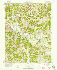
1957 Map of Cuzco
USGS Topo · Published 1958About this map
Cuzco and its surrounding hill country appear here in the late 1950s, a landscape defined by the winding course of the Patoka River and the high ground of Persimmon Ridge. The settlement pattern reflects a deeply rooted rural community, where small villages like Ellsworth, Elon, and Norton are connected by narrow roads through the Patoka Forest. The Southern railroad cuts across the northern terrain near Dillon Creek, providing a vital transit link through the township divisions of Columbia and Jackson. This survey captures the area just before significant topographical changes occurred in the river valley. Local life is anchored by landmarks such as Cane Creek Ch and several rural schoolhouses, including Cane Creek Sch and Bender Sch, which served the scattered farmsteads long after larger towns began to consolidate. Traces of early land management are visible in the alignment of the Base Line and various county boundaries.
Find a feature on this map
31 named features on this map. Tap any name to fly to it.
Don’t see what you’re looking for? This feature index may not catch every label — zoom into the map to look around manually.
Map Details
Editions of this 1957 Cuzco Map
2 editions found
Other maps of this area

1951 · Hillham
USGS Topo · 1:24,000

1951 · French Lick
USGS Topo · 1:24,000

1954 · Dubois
USGS Topo · 1:24,000

1955 · Saint Anthony
USGS Topo · 1:24,000

1956 · Greenbrier
USGS Topo · 1:24,000

1956 · Taswell
USGS Topo · 1:24,000

1956 · Rusk
USGS Topo · 1:24,000

1956 · Vincennes
USGS Topo · 1:250,000

1957 · Vincennes
USGS Topo · 1:250,000

1957 · Birdseye
USGS Topo · 1:24,000