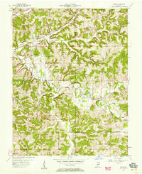
1957 Map of Cuzco
USGS Topo · Published 1969About this map
Cuzco and the surrounding timberlands of the Hoosier National Forest define this 1957 topographic study of southern Indiana. The landscape is marked by the winding course of the Patoka River and its numerous tributaries, including Painter Creek and Lick Fork, which carve through the dense ridges of Jackson and Hall townships. This era shows the region before the creation of the Patoka Lake reservoir, preserving the original locations of settlements like Ellsworth and Newton Stewart along the river banks. Transportation and community life are grounded by the Southern railroad line and local landmarks such as Cane Creek Ch and the neighboring Cane Creek Sch. The map also captures several small rural centers, including Elon, Crystal, and Norton, providing a detailed look at the scattered homesteads and family cemeteries of Dubois and Orange Counties.
Find a feature on this map
33 named features on this map. Tap any name to fly to it.
Don’t see what you’re looking for? This feature index may not catch every label — zoom into the map to look around manually.
Map Details
Editions of this 1957 Cuzco Map
2 editions found
Other maps of this area

1951 · Hillham
USGS Topo · 1:24,000

1951 · French Lick
USGS Topo · 1:24,000

1954 · Dubois
USGS Topo · 1:24,000

1955 · Saint Anthony
USGS Topo · 1:24,000

1956 · Greenbrier
USGS Topo · 1:24,000

1956 · Taswell
USGS Topo · 1:24,000

1956 · Rusk
USGS Topo · 1:24,000

1956 · Vincennes
USGS Topo · 1:250,000

1957 · Vincennes
USGS Topo · 1:250,000

1957 · Cuzco
USGS Topo · 1:24,000