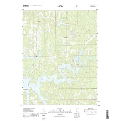
2019 Map of Greenbrier
USGS Topo · Published 2019About this map
The sprawling waters of Patoka Lake dominate this portion of the Hoosier National Forest along the border of Orange and Crawford Counties. Small settlements like Greenbrier, Ethel, and Brownstown represent the traditional communities of the region, interspersed with several family and community burial grounds including Patoka Memorial Cem, Eastridge - Fairview Cem, and Jericho Cem. The landscape is defined by the heavy indentation of the lake's fingers into the surrounding hills, creating a complex shoreline where former creek beds like Painter Cr and Cane Br now form deep inlets. Recreation and timber management are central to the area's modern character, evidenced by the extensive Springs Valley Trail 1 and Springs Valley Trail 2 systems that navigate the ridges north of the water. Prominent terrain features such as Tillery Hill and Lomax Hollow provide landmarks for those tracing the original topography before the reservoir's creation.
Find a feature on this map
31 named features on this map. Tap any name to fly to it.
Don’t see what you’re looking for? This feature index may not catch every label — zoom into the map to look around manually.
Map Details
Editions of this 2019 Greenbrier Map
This is the sole edition of this map. No revisions or reprints were ever made.
Other maps of this area

1950 · Valeene
USGS Topo · 1:24,000

1950 · English
USGS Topo · 1:24,000

1951 · Hillham
USGS Topo · 1:24,000

1951 · French Lick
USGS Topo · 1:24,000

1956 · Greenbrier
USGS Topo · 1:24,000

1956 · Taswell
USGS Topo · 1:24,000

1956 · Vincennes
USGS Topo · 1:250,000

1957 · Vincennes
USGS Topo · 1:250,000

1957 · Cuzco
USGS Topo · 1:24,000
1957 · Paoli
USGS Topo · 1:24,000