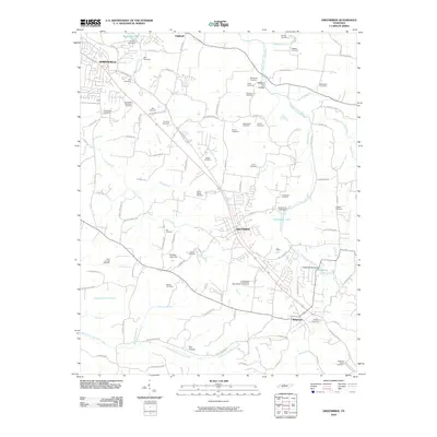
2010 Map of Greenbrier
USGS Topo · Published 2010About this map
Greenbrier and Ridgetop anchor this landscape along the Tennessee Highland Rim, where the headwaters of the Sulphur Fork Red River and North Fork Sycamore Creek carve a network of ridges and hollows. The settlement pattern is defined by traditional family holdings and small-scale water management, evidenced by the numerous cemeteries and dams found throughout the quadrangle. Genealogists will find a high density of burial sites including the Eidson Cemetery, Browing Cemetery, and Coggin Cemetery. The transition from rural farmland to residential communities is visible near the Springfield Memorial Gardens, while the rugged geography of the south is marked by features like Possum Trot Hollow and Ben Hollow. Local recreation is centered around impoundments like Greenbrier Lake and Ridgetop Lake, both held by small dams that reflect the mid-century engineering of the area.
Find a feature on this map
109 named features on this map. Tap any name to fly to it.
Don’t see what you’re looking for? This feature index may not catch every label — zoom into the map to look around manually.
Map Details
Editions of this 2010 Greenbrier Map
This is the sole edition of this map. No revisions or reprints were ever made.
Other maps of this area

1903 · Nashville
USGS Topo · 1:125,000

1931 · Ridgetop
USGS Topo · 1:62,500

1935 · Ridgetop
USGS Topo · 1:62,500

1942 · Gallatin
USGS Topo · 1:100,000

1952 · Goodlettsville
USGS Topo · 1:24,000

1952 · Springfield North
USGS Topo · 1:24,000

1952 · Youngville
USGS Topo · 1:24,000

1953 · Orlinda
USGS Topo · 1:24,000
1954 · White House
USGS Topo · 1:24,000

1955 · Whites Creek
USGS Topo · 1:24,000