
1952 Map of Springfield North
USGS Topo · Published 1953About this map
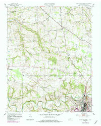
Springfield anchoring the southeast corner of this 1950s Robertson County survey shows a landscape defined by the winding course of Sulphur Fork and the Louisville and Nashville railroad. The rails connect the larger town to the community of Cedar Hill in the west, while smaller rural junctions like Kinneys and Barren Plain serve as agricultural hubs. The terrain is marked by numerous family and community landmarks, from Bartlett Cem to several schools such as Fairview Sch and Taylor Sch.
Find a feature on this map
26 named features on this map. Tap any name to fly to it.
Don’t see what you’re looking for? This feature index may not catch every label — zoom into the map to look around manually.
Map Details
Editions of this 1952 Springfield North Map
2 editions found
Other maps of this area

1903 · Nashville
USGS Topo · 1:125,000

1931 · Ridgetop
USGS Topo · 1:62,500

1935 · Ridgetop
USGS Topo · 1:62,500

1950 · Allensville
USGS Topo · 1:24,000

1951 · Adairville
USGS Topo · 1:24,000

1951 · Dot
USGS Topo · 1:24,000

1952 · Youngville
USGS Topo · 1:24,000

1956 · Nashville
USGS Topo · 1:250,000

1957 · Adams
USGS Topo · 1:24,000

1957 · Pleasant View
USGS Topo · 1:24,000