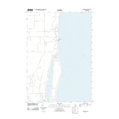
2011 Map of Greenbush
USGS Topo · Published 2011About this map
Greenbush and its quiet coastal character occupy this Lake Huron shoreline, where the community is centered around its village core and the Greenbush Post Office. The landscape is defined by the narrow strip of land separating the great lake from the long, linear Cedar Lake, creating a unique residential and recreational corridor. North-south travel is dictated by this geography, with Huron Cedar Rd and Cedar Lake Rd tracing the lake margins. Local leisure is evident in the presence of the Greenbush Golf Course to the north and Lakewood Shores Golf Course at the southern edge near Phelan Creek. Inland, the map reveals a systematic grid of township roads such as S Poor Farm Rd and E Chisholm Rd, which provide access to the rural woodlots and fields that characterize the township's interior away from the water.
Find a feature on this map
50 named features on this map. Tap any name to fly to it.
Don’t see what you’re looking for? This feature index may not catch every label — zoom into the map to look around manually.
Map Details
Editions of this 2011 Greenbush Map
This is the sole edition of this map. No revisions or reprints were ever made.
Other maps of this area

1954 · Tawas City
USGS Topo · 1:250,000

1958 · Tawas City
USGS Topo · 1:250,000

1959 · East Tawas
USGS Topo · 1:62,500

1959 · Harrisville
USGS Topo · 1:62,500

1983 · Hubbard Lake
USGS Topo · 1:100,000

1984 · Tawas City
USGS Topo · 1:100,000
1989 · Harrisville
USGS Topo · 1:24,000

1989 · Mikado
USGS Topo · 1:24,000
1989 · Lincoln
USGS Topo · 1:24,000
1989 · Greenbush
USGS Topo · 1:24,000