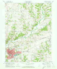
1970 Map of Greencastle
USGS Topo · Published 1972About this map
De Pauw Univ sits at the heart of Greencastle in this 1970 snapshot, where the city’s residential grid meets the industrial and transport infrastructure of central Indiana. The landscape is defined by the winding course of Big Walnut Creek and Walnut Creek, crossed by several significant structures including the Bakers Camp Covered Bridge and Houck Bridge. The map records a transition in the local rail economy, showing both the Monon and Penn Central lines intersecting near the urban center. Beyond the city limits, the rural character of Monroe, Floyd, and Marion townships is marked by numerous country churches and cemeteries, such as Brick Chapel and Old Union Cem. The presence of the Quarry and Quarry Pond indicates the local extraction industry that shaped the terrain south of the university campus.
Find a feature on this map
71 named features on this map. Tap any name to fly to it.
Don’t see what you’re looking for? This feature index may not catch every label — zoom into the map to look around manually.
Map Details
Editions of this 1970 Greencastle Map
Other maps of this area

1951 · Clinton Falls
USGS Topo · 1:24,000

1952 · Reelsville
USGS Topo · 1:24,000

1953 · Indianapolis
USGS Topo · 1:250,000

1955 · Russellville
USGS Topo · 1:24,000

1956 · Indianapolis
USGS Topo · 1:250,000

1956 · Cloverdale
USGS Topo · 1:24,000

1956 · Eminence
USGS Topo · 1:24,000

1957 · Indianapolis
USGS Topo · 1:250,000

1958 · Roachdale
USGS Topo · 1:24,000

1958 · Coatesville
USGS Topo · 1:24,000