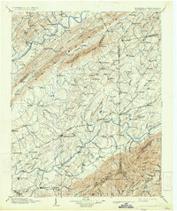
1904 Map of Greeneville
USGS Topo · Published 1934About this map
Greeneville serves as the focal point of this late 19th-century landscape, situated between the winding Nolichucky River and the Southern R. R. corridor. The map captures a transition from the agricultural river valleys to the high peaks of the Unaka National Forest, showing a network of fords and ferries essential for regional travel before modern bridging. Notable crossings like Britton Ferry on the Holston River and Jones Ford illustrate the reliance on historical water routes. The presence of Tusculum and Woolsey College highlights early educational foundations in East Tennessee. Along the rivers, landmarks such as Earnest Bridge and the Bristol and Chattanooga Line mark the infrastructure of an era defined by steam power and river navigation. Numerous small settlements, from Afton to Mosheim, reflect the dense rural population that once relied on these local hubs.
Find a feature on this map
190 named features on this map. Tap any name to fly to it.
Don’t see what you’re looking for? This feature index may not catch every label — zoom into the map to look around manually.
Map Details
Editions of this 1904 Greeneville Map
4 editions found

Other maps of this area

1883 · Morristown
USGS Topo · 1:125,000

1887 · Jonesville
USGS Topo · 1:125,000

1891 · Roan Mountain
USGS Topo · 1:125,000

1891 · Jonesville
USGS Topo · 1:125,000

1892 · Greeneville
USGS Topo · 1:125,000

1893 · Mt Guyot
USGS Topo · 1:125,000

1893 · Morristown
USGS Topo · 1:125,000

1894 · Asheville
USGS Topo · 1:125,000

1894 · Roan Mountain
USGS Topo · 1:125,000

1894 · Estillville
USGS Topo · 1:125,000