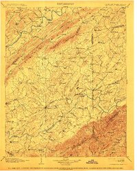
1904 Map of Greeneville
USGS Topo · Published 1913About this map
Greeneville serves as the central hub of this East Tennessee landscape, where the Southern R. R. and the Bristol and Chattanooga Line converge to move goods and people through the valley. The map reveals a society deeply integrated with its waterways, documented through a dense network of river crossings like Britton Ferry on the Holston River and Jones Ford on the Nolichucky River. Local education and industry are prominent, with landmarks such as Washington College, Woolsey College, and Bashore Mill serving as community anchors.
Find a feature on this map
176 named features on this map. Tap any name to fly to it.
Don’t see what you’re looking for? This feature index may not catch every label — zoom into the map to look around manually.
Map Details
Editions of this 1904 Greeneville Map
4 editions found

Other maps of this area

1883 · Morristown
USGS Topo · 1:125,000

1887 · Jonesville
USGS Topo · 1:125,000

1891 · Roan Mountain
USGS Topo · 1:125,000

1891 · Jonesville
USGS Topo · 1:125,000

1892 · Greeneville
USGS Topo · 1:125,000

1893 · Mt Guyot
USGS Topo · 1:125,000

1893 · Morristown
USGS Topo · 1:125,000

1894 · Asheville
USGS Topo · 1:125,000

1894 · Roan Mountain
USGS Topo · 1:125,000

1894 · Estillville
USGS Topo · 1:125,000