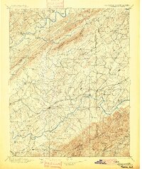
1896 Map of Greeneville
USGS Topo · Published 1900About this map
Britton Ferry and Christian Ford mark the vital river crossings of the late 19th-century East Tennessee landscape, where the Holston River and Nolichucky River dictated the flow of commerce and travel. This survey, conducted under Charles D. Walcott, captures the region's transition into a more integrated rail economy, dominated by the Southern R. R. and the Bristol and Chattanooga Line. The map reveals a dense network of small communities such as Yellow Store, Hawes X Roads, and Fall Branch, many of which were defined by their proximity to bridges and ferries like Allens Bridge and Love Ferry. To the southeast, the terrain rises sharply toward the Tennessee-North Carolina border, defined by landmarks like Fodder Stack and Camp Creek Bald. The topographic detail highlights the Quaker Knobs and numerous gaps that funneled traffic through this Appalachian corridor.
Find a feature on this map
157 named features on this map. Tap any name to fly to it.
Don’t see what you’re looking for? This feature index may not catch every label — zoom into the map to look around manually.
Map Details
Editions of this 1896 Greeneville Map
2 editions found

Other maps of this area

1883 · Morristown
USGS Topo · 1:125,000

1887 · Jonesville
USGS Topo · 1:125,000

1891 · Roan Mountain
USGS Topo · 1:125,000

1891 · Jonesville
USGS Topo · 1:125,000

1892 · Greeneville
USGS Topo · 1:125,000

1893 · Mt Guyot
USGS Topo · 1:125,000

1893 · Morristown
USGS Topo · 1:125,000

1894 · Asheville
USGS Topo · 1:125,000

1894 · Roan Mountain
USGS Topo · 1:125,000

1894 · Estillville
USGS Topo · 1:125,000