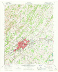
1961 Map of Greeneville
USGS Topo · Published 1964About this map
The historic town of Greeneville serves as the focal point of this early 1960s landscape, where urban development radiates outward toward the neighboring communities of Tusculum and Eastview. Significant cultural landmarks are concentrated in the town center, including the Andrew Johnson Home and the Andrew Johnson National Cemetery, preserving the legacy of the 17th U.S. President. The local economy and infrastructure are defined by the Southern Railway corridor and the Andrew Johnson Highway, which cut through the ridges and valleys characteristic of East Tennessee.
Find a feature on this map
68 named features on this map. Tap any name to fly to it.
Don’t see what you’re looking for? This feature index may not catch every label — zoom into the map to look around manually.
Map Details
Editions of this 1961 Greeneville Map
3 editions found
Other maps of this area

1892 · Greeneville
USGS Topo · 1:125,000

1896 · Greeneville
USGS Topo · 1:125,000

1904 · Greeneville
USGS Topo · 1:125,000

1935 · Surgoinsville
USGS Topo · 1:48,000

1935 · Baileyton
USGS Topo · 1:24,000

1935 · McCloud
USGS Topo · 1:24,000

1935 · Mosheim
USGS Topo · 1:24,000

1935 · Cedar Creek
USGS Topo · 1:24,000

1935 · Fall Branch
USGS Topo · 1:48,000
1935 · Jearoldstown
USGS Topo · 1:24,000