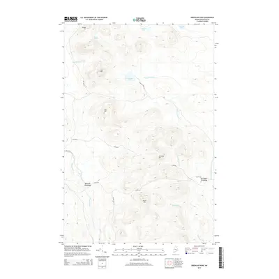
2014 Map of Greenlaw Pond
USGS Topo · Published 2014About this map
Greenlaw Crossing and Russell Crossing mark the sparse intersections of this remote timberland in northern Maine. The landscape is defined by a dense network of waterways and prominent peaks, including Greenlaw Mtn and Orcutt Mtn. The Machias River flows through the western portion of the territory, while the namesake Greenlaw Pond feeds into Greenlaw Stream as it moves toward the southeast. These drainage patterns illustrate the complex topography of the t12r8 Wels township. Logging and access routes like Reality Rd and Fish Lake Rd provide the primary infrastructure through the woods. Other notable water features include Bishop Pond, Sterling Pond, and Moosehorn Stream, which are scattered among high points such as Bald Mtn and Bull Hill.
Find a feature on this map
20 named features on this map. Tap any name to fly to it.
Don’t see what you’re looking for? This feature index may not catch every label — zoom into the map to look around manually.
Map Details
Editions of this 2014 Greenlaw Pond Map
This is the sole edition of this map. No revisions or reprints were ever made.
Other maps of this area

1928 · Winterville
USGS Topo · 1:48,000

1930 · Greenlaw
USGS Topo · 1:48,000

1931 · Fish River Lake
USGS Topo · 1:48,000

1931 · Mooseleuk Lake
USGS Topo · 1:48,000

1931 · Winterville
USGS Topo · 1:62,500

1933 · Greenlaw
USGS Topo · 1:62,500

1935 · Fish River Lake
USGS Topo · 1:62,500

1935 · Mooseleuk Lake
USGS Topo · 1:62,500

1954 · Presque Isle
USGS Topo · 1:250,000

1958 · Presque Isle
USGS Topo · 1:250,000
Featured Places
- Greenlaw Crossing, T12 R7 WELS
- Russell Crossing, T11 R8 WELS
- T11 R7 WELS, ME
- T12 R8 WELS, ME
- T11 R8 WELS, ME