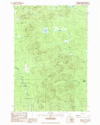
1986 Map of Greenlaw Pond
USGS Topo · Published 1986About this map
The Machias River winds through this heavily forested section of Aroostook County, defining a landscape of remote timberlands and isolated crossings. In the mid-1980s, the area remained largely defined by its township boundaries, such as T 12 R 8 W E L S, with few permanent settlements. Human activity is concentrated around Russell Crossing and Greenlaw Crossing, where primitive roads meet the river and streams. The terrain is marked by significant elevations like Greenlaw Mountain and Orcutt Mountain, which overlook a network of water bodies including Greenlaw Pond and the smaller Bishop Pond. This survey illustrates a working forest environment, where a single Gravel Pit and a web of private roads provide the only infrastructure amidst the dense network of waterways like Moosehorn Stream and Carr Pond Stream.
Find a feature on this map
26 named features on this map. Tap any name to fly to it.
Don’t see what you’re looking for? This feature index may not catch every label — zoom into the map to look around manually.
Map Details
Editions of this 1986 Greenlaw Pond Map
This is the sole edition of this map. No revisions or reprints were ever made.
Other maps of this area

1928 · Winterville
USGS Topo · 1:48,000

1930 · Greenlaw
USGS Topo · 1:48,000

1931 · Fish River Lake
USGS Topo · 1:48,000

1931 · Mooseleuk Lake
USGS Topo · 1:48,000

1931 · Winterville
USGS Topo · 1:62,500

1933 · Greenlaw
USGS Topo · 1:62,500

1935 · Fish River Lake
USGS Topo · 1:62,500

1935 · Mooseleuk Lake
USGS Topo · 1:62,500

1954 · Presque Isle
USGS Topo · 1:250,000

1958 · Presque Isle
USGS Topo · 1:250,000