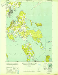
1947 Map of Greenport
USGS Topo · Published 1947About this map
The maritime village of Greenport serves as the focal point for this mid-century survey of the Peconic Bay region, showing a dense network of piers and wharves concentrated around Greenport Harbor and the Stirling Basin. Across the water, Shelter Island dominates the central landscape, connected by its unique geography of coves and necks like West Neck and Ram Island. The road network of the era is well-defined, with Stearns Point Road and Cobbetts Lane winding through the islands. Further south, the map details the settlement at North Haven and the northern edge of Sag Harbor, illustrating the complex water-based boundaries of Southampton and East Hampton. Small inland water features such as Silver Lake and Fresh Pond provide essential landmarks for local history researchers and genealogists tracing family lands near the various points and creeks.
Find a feature on this map
64 named features on this map. Tap any name to fly to it.
Don’t see what you’re looking for? This feature index may not catch every label — zoom into the map to look around manually.
Map Details
Editions of this 1947 Greenport Map
This is the sole edition of this map. No revisions or reprints were ever made.
Other maps of this area

1903 · Sag Harbor
USGS Topo · 1:62,500

1903 · Gardiners Island
USGS Topo · 1:62,500

1904 · Sag Harbor
USGS Topo · 1:62,500

1904 · Shelter Island
USGS Topo · 1:62,500

1904 · Easthampton
USGS Topo · 1:62,500

1904 · Gardiners Island
USGS Topo · 1:62,500

1921 · Gardiners Island
USGS Topo · 1:62,500

1921 · Easthampton
USGS Topo · 1:62,500

1944 · Gardiners Island West
USGS Topo · 1:24,000

1946 · Sag Harbor
USGS Topo · 1:24,000