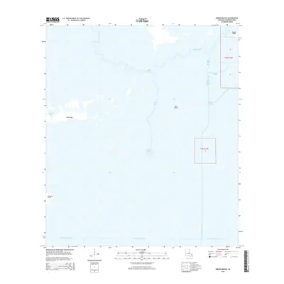
2015 Map of Greens Bayou
USGS Topo · Published 2015About this map
Lone Pine sits at the northeastern edge of this coastal marsh landscape in Cameron Parish, marking a transition point in the complex wetlands of southwestern Louisiana. The terrain is defined by a intricate system of natural waterways and early industrial drainage efforts, including the Black Bayou and Greens Bayou systems. The map illustrates how human intervention has reshaped the marsh through an extensive network of waterways such as the Starks Central Canal, Burton-Sutton Canal, and Willow Bayou Canal. These straight-line channels contrast sharply with the wandering paths of the bayous and the irregular shapes of Greens Lake and Blue Islands. This 2015 data provides a clear record of the low-lying coastal topography, capturing family-named landmarks like Marceaux Island and the subtle elevation of Pines Ridge amidst the surrounding bayous.
Find a feature on this map
18 named features on this map. Tap any name to fly to it.
Don’t see what you’re looking for? This feature index may not catch every label — zoom into the map to look around manually.
Map Details
Editions of this 2015 Greens Bayou Map
This is the sole edition of this map. No revisions or reprints were ever made.
Other maps of this area
1932 · Orange
USGS Topo · 1:62,500
1932 · Port Arthur NE
USGS Topo · 1:31,680
1934 · Johnsons Bayou
USGS Topo · 1:24,000
1934 · Peveto Beach
USGS Topo · 1:24,000
1934 · Greens Bayou
USGS Topo · 1:24,000
1934 · Five Lakes
USGS Topo · 1:24,000
1935 · Peveto Beach
USGS Topo · 1:31,680
1935 · Five Lakes
USGS Topo · 1:31,680
1935 · Greens Bayou
USGS Topo · 1:31,680
1935 · Johnsons Bayou
USGS Topo · 1:31,680