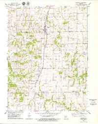
1979 Map of Greentop
USGS Topo · Published 1979About this map
The Norfolk and Western railroad forms the central north-south spine of this 1970s landscape, connecting the town of Greentop and the small settlement of Sublette. This survey captures the rural character of the borderlands between Schuyler and Adair counties, where small family farms are divided by topographic features like Floyd Creek and the North Fork Salt River. Beyond the rail corridor, the map reveals a community structured around its local institutions, from country churches such as New Harmony Ch and Madison Ch to family burial grounds like Fugate Cem and Towles Cem. A distinctive insight into the era's land use is found in the inclusion of selected fence and field lines, noted as being visible on aerial photography, providing a clear picture of agricultural patterns before modern consolidation altered many of these historic property boundaries.
Find a feature on this map
27 named features on this map. Tap any name to fly to it.
Don’t see what you’re looking for? This feature index may not catch every label — zoom into the map to look around manually.
Map Details
Editions of this 1979 Greentop Map
This is the sole edition of this map. No revisions or reprints were ever made.
Other maps of this area

1903 · Edina
USGS Topo · 1:125,000

1911 · Queen City
USGS Topo · 1:62,500

1913 · Queen City
USGS Topo · 1:62,500

1938 · Kirksville
USGS Topo · 1:62,500

1940 · Kirksville
USGS Topo · 1:62,500

1954 · Centerville
USGS Topo · 1:250,000

1957 · Centerville
USGS Topo · 1:250,000

1958 · Centerville
USGS Topo · 1:250,000

1965 · Downing NW
USGS Topo · 1:24,000

1966 · Brashear
USGS Topo · 1:24,000