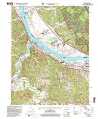
2002 Map of Greenup
USGS Topo · Published 2006About this map
The Ohio River carves a deep valley through the borderlands of Kentucky and Ohio, serving as a primary corridor for the Chesapeake and Ohio railroad and heavy industrial sites like Franklin Furnace. The landscape is defined by the contrast between the flat, developed floodplains near Greenup and the labyrinth of steep hollows such as Big Doney Hollow and Coal Bank Hollow that stretch into the interior. On the Ohio side, the French Grants lands reveal a unique surveying history, while the Kentucky side shows dense settlement expansion at Wurtland and Raceland Junction. Family history is deeply rooted in the terrain, with numerous small burial grounds like Gilruth-Davisson Cem and Cochran Cem tucked away near the winding courses of the Little Sandy River and Tygarts Creek.
Find a feature on this map
55 named features on this map. Tap any name to fly to it.
Don’t see what you’re looking for? This feature index may not catch every label — zoom into the map to look around manually.
Map Details
Editions of this 2002 Greenup Map
This is the sole edition of this map. No revisions or reprints were ever made.
Other maps of this area

1898 · Ironton
USGS Topo · 1:62,500

1900 · Ironton
USGS Topo · 1:62,500

1901 · Ceredo
USGS Topo · 1:62,500

1903 · Kenova
USGS Topo · 1:125,000

1904 · Kenova
USGS Topo · 1:125,000

1913 · Ceredo
USGS Topo · 1:62,500

1926 · Greenup
USGS Topo · 1:48,000

1930 · Greenup
USGS Topo · 1:62,500

1953 · Oldtown
USGS Topo · 1:24,000
1953 · Load
USGS Topo · 1:24,000