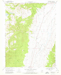
1969 Map of Greenwich
USGS Topo · Published 1978About this map
Greenwich serves as a small anchor for this 1969 topographic study, situated along the base of the steep western slopes of Fishlake National Forest. The landscape is dominated by the sharp transition between the agricultural floor of Grass Valley and the high mountain terrain. Water management is central to the area's geography, evidenced by the Upper Box Creek Reservoir and Box Creek Reservoir positioned in the higher elevations to catch runoff for the valley below.
Find a feature on this map
31 named features on this map. Tap any name to fly to it.
Don’t see what you’re looking for? This feature index may not catch every label — zoom into the map to look around manually.
Map Details
Editions of this 1969 Greenwich Map
2 editions found
Other maps of this area

1885 · Beaver
USGS Topo · 1:250,000

1885 · Fish Lake
USGS Topo · 1:250,000

1896 · Fish Lake
USGS Topo · 1:250,000

1940 · Monroe
USGS Topo · 1:62,500

1944 · Monroe
USGS Topo · 1:62,500

1945 · Marysvale
USGS Topo · 1:62,500

1947 · Marysvale
USGS Topo · 1:62,500

1953 · Richfield
USGS Topo · 1:250,000

1956 · Salina
USGS Topo · 1:250,000

1958 · Richfield
USGS Topo · 1:250,000